Daily Update

November 23rd Update

Chilly conditions and clear skies look to be the story for the region heading into the week of Thanksgiving. After quite the cold start, temperatures look to moderate ever so slightly as we progress through the week, with the next chance of precipitation not expected to arrive until Saturday at the earliest.

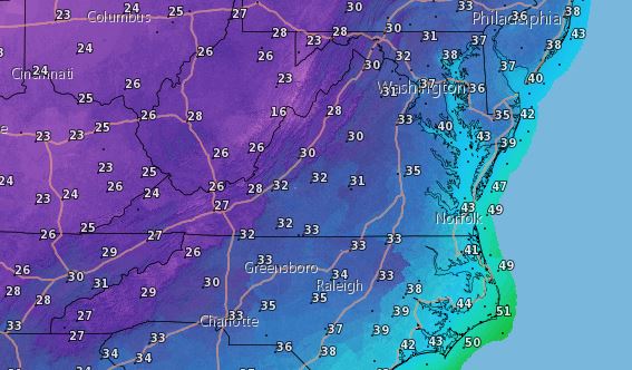
A high pressure system is currently in control of our region, helping to keep some cold air in our area. This pattern doesn’t look to change much through Wednesday, meaning clear skies at night and very cold mornings will be the story for us over the next couple of days. If you can get past the cold conditions, there will plenty of sunshine to go around over the coming days. Sunshine will be the dominating weather feature for us today, with high temperatures poised to reach only into the upper 30s to mid 40s across the region by days end. Clear skies across the area tonight will allow for temperatures to plummet into the mid 20s to lower 30s.

Low Temps
Clear skies will lead to a few more very cold mornings over the next couple of days. (NWS)

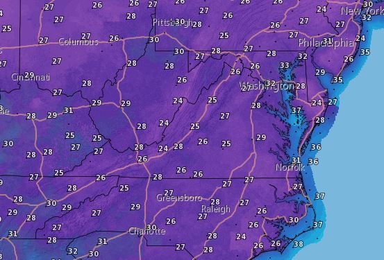
Tuesday looks to continue the trend with another sunny and slightly warmer day. While you may still need to dress in a few layers tomorrow, highs will top out around the upper 40s to lower 50s; a welcome “warm-up” to the conditions we saw yesterday and will see today. Any warming we do gain will be lost to another clear to partly cloudy sky tomorrow night, meaning lows will again drop down into the mid 20s to lower 30s once more across the region.

The day before Thanksgiving looks to be on the sunny side, with the slight warming trend expected to continue. Highs will reach into the upper 40s to mid 50s by the end of the day. All things considered, Wednesday should be a good day for any travel or shopping plans you may have as long as you keep a jacket nearby. Just a few more clouds stream in overhead Wednesday night, with lows expected to bottom out in the upper 20s to mid 30s across the region.

Other than a marginal increase in cloudiness, the Thanksgiving holiday currently looks to be fairly pleasant with no precipitation to spoil any plans. In fact, we should reach into the 60s by the end of the day Friday, so you couldn’t ask for better conditions to get some holiday shopping done. A cold front looks to bring our next chance for some rain to the region late Friday evening and into the day Saturday. A complete washout isn’t expected at the moment, but an umbrella or rain jacket looks like it could definitely come in handy.

Thanks as always for tuning in and be sure to check back here throughout the week for the latest updates!

Daily Update

November 18th Update

A strong cold front is currently approaching our region, bringing with it a great deal of rain to the area over the next day or so. Skies will clear out by Friday, meaning we can look forward to a relatively pleasant end to the work week. With that being said, another front moves through the area on Saturday, with the primary weather story this time being a significant drop in temperatures.

High pressure is expected to begin exiting our region today, as a cold front begins to push into the area by the end of the day from the west. This front looks to deliver a great deal of rain to the state beginning this evening and continuing through the day Thursday. The Weather Prediction Center believes that 1 to 2 inches of rainfall isn’t out the question, with some of the higher elevations of the Blue Ridge possibly receiving more. Rain gear will be an absolute must for your daily commute today and tomorrow. Cloud coverage will remain dense today, with highs expected to reach into the lower to upper 60s across the state. Some light rain will begin to fall in the far western fringe of the state by the late afternoon hours, but expect the bulk of the precipitation to begin later this evening and into the early morning hours of our Thursday. Gusty winds will also be possible with this front (20-30 MPH), especially for the westernmost areas of the state (where some gusts could reach into the 40-50 MPH range). Lows will dip down into the mid 50s to lower 60s across the state tonight, with rain and cloudy conditions continuing.

WPC QPF
The Weather Prediction Center’s quantitative precipitation forecast for this morning through Friday morning. 1-2 inches of rain on the way, with potentially more for the highest elevations. (NOAA, NWS, WPC)

Thursday will bring much of the same to region, so please be sure to bring that rain jacket or umbrella with you as you head out the door! Also be sure to be careful out on the roadways. Rain will continue throughout the day, but mostly in the hit or miss rain shower variety. In other words, not nearly as widespread or heavy as what we will see this evening. Clouds, however, will stick around for a while tomorrow before clearing out tomorrow evening. High temperatures for your Thursday look to reach into the lower 60s to lower 70s in some locations east of the Blue Ridge Mountains. We should be entirely cleared out of any lingering cloud coverage or precipitation by tomorrow evening. Clear conditions Thursday night will allow for lows to drop into the upper 30s to mid 40s across the region.

Abundant sunshine will return to the area by Friday to round off the work week, albeit with some cooler temperatures compared to what we have seen over the past several days. Highs will top out in the lower to upper 50s by days end on Friday. Those temperatures and an occasional gusty wind or two will make a light jacket a necessity. Clear conditions Friday night will spell out another cold evening for our region, with lows expected to hover in the lower to upper 30s across the state.

Low Temps

If you aren’t a fan of the cold weather, I have some bad news for you. Another cold front looks to begin impacting the region on Saturday, delivering with it some of the coldest air we have seen yet this fall. Temperatures on Sunday morning will be be in the 20s for some locations along the Blue Ridge, and everyone will struggle to get into the 40s by the end of the day. In fact, don’t be surprised to see a few flurries early Sunday morning if you live in the highest elevations of the Blue Ridge. We should begin to warm back up heading into the beginning and middle portions of next week, but you’ll definitely need that winter jacket this weekend.